Use Docker to deploy your application
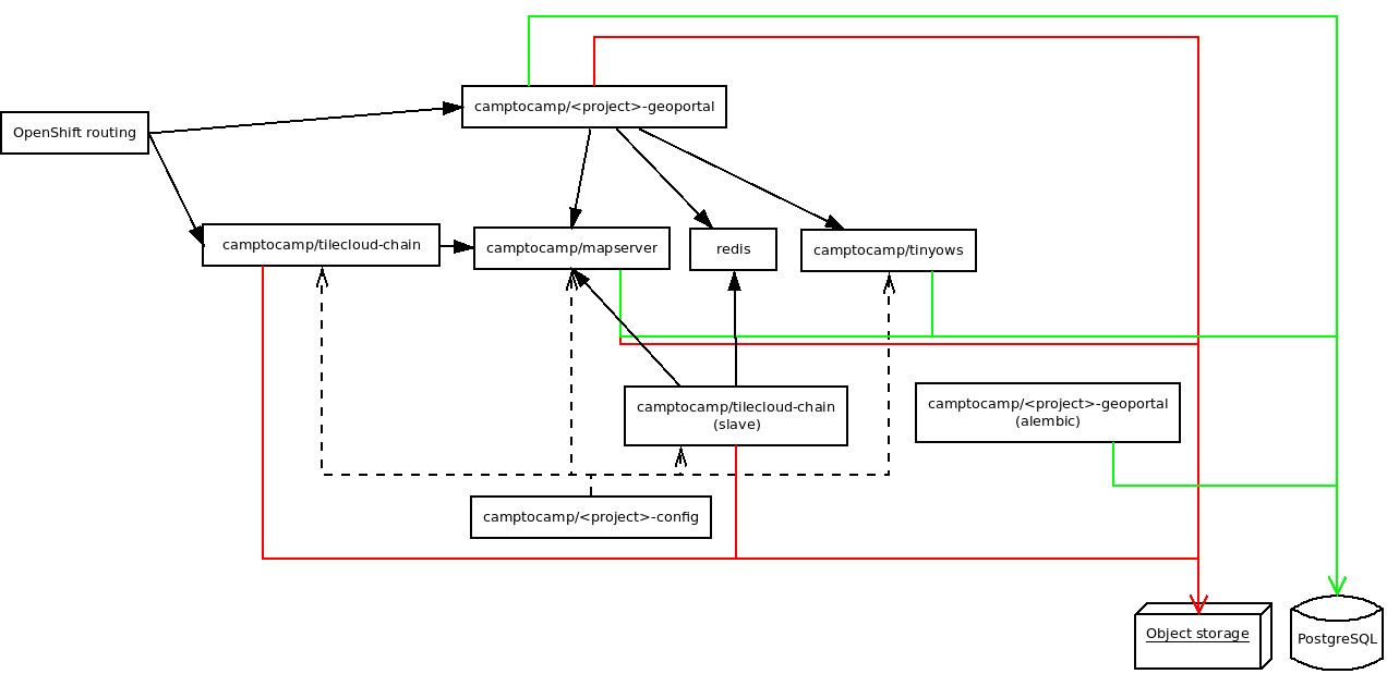
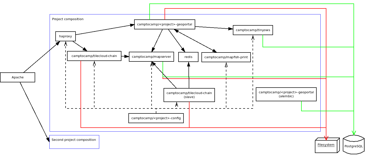
Architecture schema
For OpenShift projects:
For stand alone projects:
Docker Images
When you build your application, the following images will be generated:
camptocamp/<package>_geoportal:latestcamptocamp/<package>_config:latest
The tag is by default latest, but you can change it by setting the DOCKER_TAG Makefile variable.
Docker compose files
docker-compose.yaml: The main file that describes the composition.docker-compose-lib.yaml: Provideis the base description of Geomapfish Docker services..env: Generated from the env files; contains the environment variables used by the composition.docker-compose.override[.sample].yaml: Some rules for debuggung..env: The variable used in the compose files.
Run the developer composition
docker-compose up -d
You can then access your application with https://localhost:8484/.
Clean
Docker does not clean anything automatically, in particular it does not clean any images, therefore disk space may become problematic after a certain number of builds. You can use the following commands to manually remove Docker files.
Use docker system prune to clean files; you can add the --all option to do a deeper clean.
Environment variables
The GeoMapFish containers can be customised with some environment variables:
Config:
VISIBLE_WEB_HOST: The web host visible by the browser e.-g.: ‘example.com’.
VISIBLE_ENTRY_POINT: The web path visible by the browser e.-g.: ‘/main/’, default is ‘/’.
PGSCHEMA: The postgres schema, used by mapserver.
GEOPORTAL_INTERNAL_URL: Used by the print in non mutualised mode.
TILECLOUDCHAIN_INTERNAL_URL: Used by the print in non mutualised mode.
ST_JOIN: Can beST_Collect(default) orST_Union,ST_Collectis better for performance but does not support restriction area intersection.
Geoportal:
VISIBLE_ENTRY_POINT: The web path visible by the browser e.-g.: ‘/main/’, default is ‘/’.
PGSCHEMA: The postgres schema, used by mapserver.
AUTHTKT_TIMEOUT: See: Authentication.
AUTHTKT_REISSUE_TIME: See: Authentication.
AUTHTKT_MAXAGE: See: Authentication.
AUTHTKT_SECRET: See: Authentication.
AUTHTKT_COOKIENAME: See: Authentication.
AUTHTKT_HTTP_ONLY: See: Authentication.
AUTHTKT_SECURE: See: Authentication.
AUTHTKT_SAMESITE: See: Authentication.
BASICAUTH: See: Authentication.
LOG_TYPE: Should be ‘console’ with Docker Compose and ‘json’ with OpenShift.
LOG_LEVEL: Log level for your application, default isINFO, can beDEBUG,INFO,WARNING,ERROR,CRITICALorNOTSET, see also theproduction.inifile and the logging documentation.
C2CGEOPORTAL_LOG_LEVEL: Log level for all c2cgeoportal modules, default isWARN.
C2CWSGIUTILS_LOG_LEVEL: Log level for c2cwsgiutils, default isINFO.
GUNICORN_LOG_LEVEL: Log level for Gunicorn, default isINFO.
SQL_LOG_LEVEL: Log level for the Sqlalchemy engine``, default isWARN.
DOGPILECACHE_LOG_LEVEL: Log level for Dogpile cache, default isINFO.
OTHER_LOG_LEVEL: Log level for other modules, default isWARN.
QGIS server:
GEOMAPFISH_CONFIG: The GeoMapFish config file, default is/etc/qgisserver/geomapfish.yaml.
GEOMAPFISH_OGCSERVER: The OGC server name in single QGIS project mode.
GEOMAPFISH_ACCESSCONTROL_CONFIG: The access control config file for multi QGIS project mode.
GEOMAPFISH_POSITION: The plugin position, Default is100.
LOG_LEVEL: Log level for the GeoMapFish plugins, see also thelogging.inifile.
C2CGEOPORTAL_LOG_LEVEL: Log level for all c2cgeoportal modules, default isINFO.
C2CWSGIUTILS_LOG_LEVEL: Log level for c2cwsgiutils, default isINFO.
SQL_LOG_LEVEL: Log level for the Sqlalchemy engine``, default isWARN.
OTHER_LOG_LEVEL: Log level for other modules, default isWARN.
QGIS_SERVER_LOG_LEVEL: Qgis server log level, default is2,0for verbose.
CPL_VSIL_CURL_USE_CACHE: GDAL option, default isTRUE.
CPL_VSIL_CURL_CACHE_SIZE: GDAL option, default is128000000.
CPL_VSIL_CURL_USE_HEAD: GDAL option, default isFALSE.
GDAL_DISABLE_READDIR_ON_OPEN: GDAL option, default isTRUE.